
Small satellite positioning LEO and satellite orbit determination using Galileo

The current challenges and vulnerability of satellite positioning, or GNSS (Global Navigation Satellite Systems), have accelerated the development towards more accurate, safer and reliable positioning. One part of this development is the new low-orbit (less than 2,000 km) Low Earth Orbit (LEO) small satellites.
These satellites are already used for telecommunications, for example, but future LEO satellite positioning has been tailored to produce the signal needed for positioning, navigation and timing (PNT) purposes.
The advantages of LEO-based satellite constellation compared to existing GNSS systems have recently been extensively studied and can partly cover the limitations of existing GNSS systems, such as the challenges of weak signals and the need for encryption of open and unprotected signals. Researchers from the National Land Survey of Finland's Finnish Geospatial Research Institute (FGI) are involved in the development of a new type of LEO-GNSS receiver designed to respond to future positioning needs in applications critical to society. The LEO-PNT receiver is a new way to implement the secure, accurate and reliable positioning required by these applications. The European Space Agency (ESA) has launched a new LEO-PNT programme involving FGI researchers.
The LEO-PNT receiver being developed by the Geospatial Research Institute is designed to be used on the ground and can also be used to determine the locations of LEO satellites. The Geospatial Research Institute is also studying the positioning of LEO satellites with the help of Galileo data. Currently, we have a monitoring station at the FGI that continuously records Galileo High Accuracy Service (HAS) corrections in real-time. Figure 1 shows a schematic of the monitoring station setup. The performance of these new methods will be continuously monitored and improved.
FGI has also developed real-time exact track definition for LEO satellites (Precise Orbit Termination - POD). The openly available LEO satellite data of the European Space Agency (ESA) have been used for this purpose. The Galileo HAS data can be used to locate LEO satellites and it has reached an accuracy of 28.5 cm when using a two-frequency GNSS receiver (see figure 1).
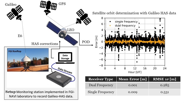
Figure 1: Accuracy comparison of kinematic track specification for LEO satellites. The track configuration has been made for SWARM LEO satellites using two-frequency GNSS data and Galileo HAS corrections.
We have compared track configuration with track data produced without the HAS service. At best, the accuracy has been several metres, so the improvement produced by Galileo HAS is significant here. For this reason, the use of Galileo HAS for track identification is a step forward in the development of LEO positioning, since accurate track identification is vital for satellite positioning systems, even though it is rarely visible to users. In Finland, this capability is maintained for traditional GNSS systems at the National Land Survey of Finland in Metsähovi Geodetic Research Station. From the user's point of view, this has the most visible effect on the accuracy of the positioning receiver, which essentially depends on the accuracy of satellite track data, and therefore the results obtained with Galileo HAS are very promising.
Zahidul Bhuiyan
Fabricio Dos Santos Prol
Sanna Kaasalainen
National Land Survey of Finland


